Hiking the White Mountains: Peaks, Climate, and What to Know
There’s nothing quite like setting foot on a trail in New Hampshire’s White Mountains. With jagged ridgelines, dense forests, alpine summits, and unpredictable weather, this mountain range offers both challenge and reward. Below is a look at the peaks, climate zones, and essential considerations for anyone planning a hike in this iconic region.
The White Mountains at a Glance
The White Mountains sit in northern New Hampshire, extending slightly into Maine, and form part of the greater Appalachian range. They include the rugged Presidential Range, the Franconia Range, the Pemigewasset Wilderness, and numerous subranges and spurs.
A hallmark of this area is the “4,000-footers” list — 48 named peaks in the White Mountains that rise to at least 4,000 feet. Hiking all 48 is a classic New England challenge.
Within those peaks are some heavy hitters. Mount Washington (6,288 ft) is the tallest in the Northeast and dominates many hiking conversations. Others like Mount Lafayette (5,249 ft) lead the Franconia Range, with dramatic ridges and exposed traverses. Peaks such as Mount Flume (4,328 ft), Mount Osceola (4,340 ft), East Osceola (4,156 ft), and Mount Cabot (4,160+ ft) offer strong day-hike options or stepping stones to longer ridge trips.
One of the more epic routes is the Pemi Loop in the Pemigewasset Wilderness, roughly 32 miles, which links eight 4,000-foot summits and includes a traverse of Franconia Ridge. Other popular traverses include the Presidential Range’s ridgeline (the “Prezi Traverse”) or shorter loops in Franconia Notch combining Lafayette, Lincoln, Liberty, and surrounding peaks.
Elevation & Climate Zones: From Forest to Alpine
One of the most striking aspects of hiking the Whites is how fast the environment changes with elevation. As you climb, you’ll pass through distinctly different ecozones, each with its own flora, fauna, and weather behavior.
-
Lower Mixed Northern Forest (≈ 1,500–2,500 ft): You’ll start among hardwoods like maple, birch, and beech, transitioning gradually to conifers such as spruce and fir as altitude rises. Moisture, soil acidity, and wind shape the forest composition.
-
Boreal / Subalpine Zone: As you gain altitude, the tree line begins to thin, and species grow stunted in “krummholz” form — twisted, wind-pruned trees. The soil becomes more acidic, and nutrients are washed downward by frequent rain and snow.
-
Alpine / Summit Zone: On peaks like Washington, Lafayette, and others above 4,500–5,000 ft, vegetation becomes sparse — low grasses, cushion plants, lichens, and hardy alpine flowers adapted to short growing seasons and intense winds.
This progression means that a hike from base to summit may feel like walking through three different ecosystems in a single day. It also helps explain why the weather shifts so abruptly with height.
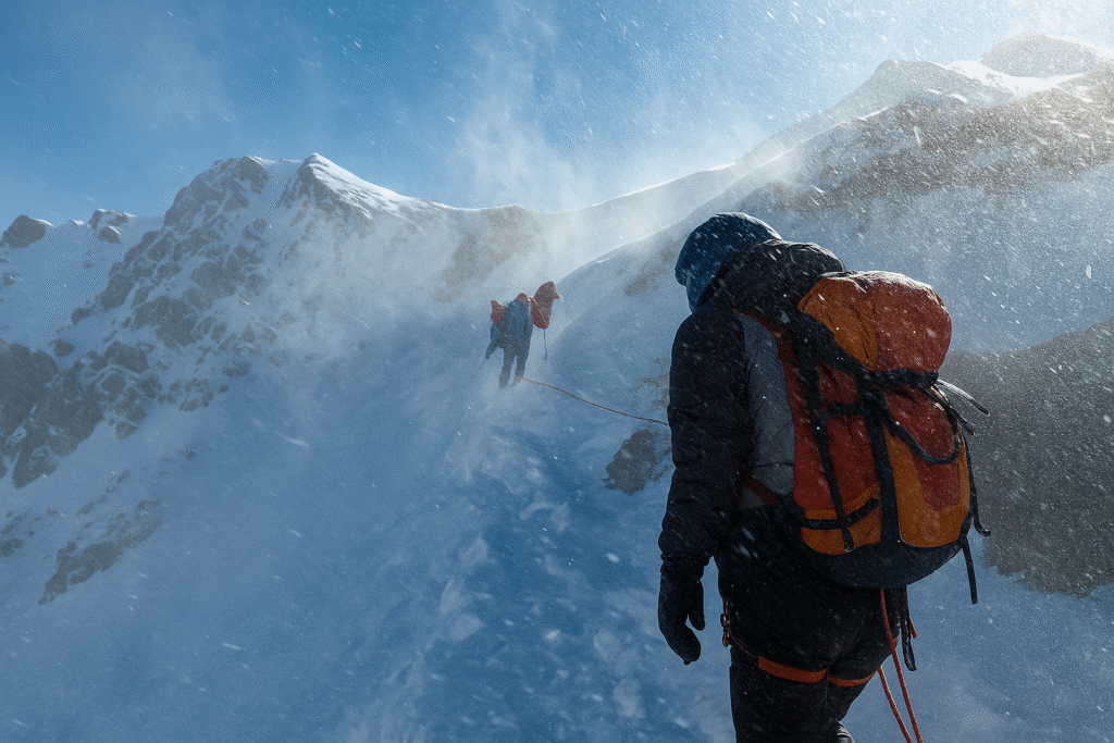
Weather & Climate: Unpredictable and Extreme
If the White Mountains have a reputation, it’s this: the weather can change faster than you can adjust your layers.
Mount Washington sits at the crossroads of several major storm tracks and has recorded some of the highest wind speeds on earth, over 200 mph. Even on calm valley days, hikers on exposed ridges can face gale-force gusts.
Temperature swings are equally dramatic — it’s not uncommon for summit temperatures to be tens of degrees colder than at the trailhead. Even in mid-summer, strong winds or sudden fronts can bring freezing rain or snow.
Fog and low visibility are frequent, and lightning storms present serious risks, especially above treeline. Snow and ice can appear well into spring and return early in autumn, often lingering on high ridges. Microspikes or crampons are essential outside the warmest summer months.
The most reliable hiking season generally runs from June through early October, though experienced mountaineers venture out year-round. Given the conditions, it’s vital to layer properly, carry wind and rain protection, check forecasts repeatedly, and be ready to turn back.
Highlights & Trail Ideas
Here are a few standout hikes and peak combinations to consider:
-
Mount Washington via Tuckerman Ravine Trail – The most iconic ascent, featuring steep, rocky terrain, a challenging headwall, and sweeping summit views.
-
Franconia Ridge Loop – Combines Lafayette, Lincoln, and Little Haystack in one of New England’s most scenic ridge walks. About 8.9 miles with nearly 4,000 feet of elevation gain.
-
Pemi Loop (32 mi) – A demanding backpacking route through the Pemigewasset Wilderness, linking Bondcliff, Garfield, South Twin, and more.
-
Arethusa Falls – A short, family-friendly trail leading to one of New Hampshire’s tallest waterfalls, about 2.8 miles round trip.
-
Mount Flume & Liberty – Reachable from Lincoln Woods via the Osseo or Liberty Spring trails, these peaks offer commanding views of Franconia Notch.
-
Mount Osceola & East Osceola – Moderate but rewarding climbs with sweeping vistas toward Mount Washington and Waterville Valley.
-
Mount Cabot – A quieter, northern peak known for its isolation and forested trails.
Beyond hiking, the Appalachian Mountain Club (AMC) maintains a network of high-mountain huts throughout the White Mountains, allowing multi-day traverses with shelter and meals along the way.
Safety & Best Practices
Whether you’re planning a day hike or a multi-day traverse, safety starts with preparation:
-
Carry the 10 Essentials — Map, compass, headlamp, extra layers, food, water, first aid, and a reliable way to navigate.
-
Start Early — Begin before sunrise for longer hikes; afternoon storms and short daylight hours can complicate descents.
-
Check Summit Forecasts — Conditions on top can differ drastically from the base. Always consult Mount Washington Observatory or AMC reports.
-
Turn Around If Necessary — Many accidents occur when hikers push on despite deteriorating weather.
-
Pack Smartly — Use breathable, layered clothing, waterproof shells, and traction gear when needed.
-
Respect Fragile Alpine Vegetation — Stay on durable rock surfaces and avoid trampling rare alpine plants.
-
Watch for Hypothermia and Wind Chill — Even mild days can become dangerous if you’re wet and exposed.
-
Know Current Trail Conditions — Check reports and seasonal advisories before heading out.
Even experienced hikers have faced dangerous situations when weather or footing turned suddenly. Preparation, awareness, and respect for the environment remain the keys to a safe and fulfilling trip.
Final Thoughts
If you’re drawn to rugged climbs, sweeping ridgelines, and alpine air, the White Mountains deliver in every way. From beginner-friendly outings like Arethusa Falls to legendary routes like the Presidential Traverse or the Pemi Loop, there’s something here for every type of hiker — provided you come prepared.
The terrain and weather demand respect, but the payoff is immense: sunrise over endless peaks, crisp air above treeline, and the feeling of accomplishment that only the Whites can offer. Lace up, plan carefully, and let these mountains remind you why New Hampshire truly is the Granite State.
Sources
-
Visit White Mountains NH – “Top White Mountains Hiking Trails”
-
AMC Outdoors – “In the Zone: Exploring the Ecozones of the White Mountains”
-
The Big Outside – “The Best Hikes in the White Mountains”
-
Wildland Trekking – “Hiking the White Mountains Presidential Range”
-
Trekking Sketches – “New Hampshire 48 (the 4,000 Footers List)”
-
Wikipedia – “Mount Lafayette,” “Mount Flume,” “Mount Osceola,” “Mount Cabot”
-
AP News – “Hiker Dies in White Mountains After Falling in Icy Conditions”; “Freezing Hikers Stuck in Waist-Deep Snow Rescued”